UNIFLY PRODUCTS
Functionalities for UAS and UAM operators
For operators, the Unifly UTM platform eases the flight process by offering services to prepare, plan, validate, fly, address issues, and report on drone & UAM activities. A publicly accessible web-based application provides essential airspace restriction information. For more complex operations, the platform delivers in-depth planning and validation services for safer flights, alongside live flight monitoring, in-flight conflict resolution features, and comprehensive reporting and analysis post-flight. This ensures that operators can manage their flights efficiently and safely from beginning to end.
Explore
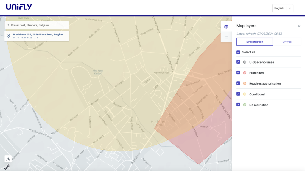
“Explore” delivers a comprehensive mapping solution tailored for drone operators, featuring:
Public Web-Based Map: A real-time, interactive map publicly accessible, providing operators with information on airspace restrictions and critical flight details.
Customer-Branded Interface: A customizable interface that can be branded for specific customers, with tailored policies and terms and conditions.
Airspace and Geozone Information: Showcases various airspace categories and geozones, such as heliports, temporary no-fly zones, airports, and prisons, along with specific access conditions for drones.
Advanced NOTAM Parsing: The platform meticulously interprets every line of an ICAO NOTAM, not just the commonly used Q-line. It employs a sophisticated language processor developed from a comprehensive collection of ICAO NOTAM catalogs from multiple countries. This ensures the highest accuracy in depicting airspace restrictions and operational conditions.
Multi-Language Support: The web-based map is accessible in multiple languages.
This suite of features ensures drone operators can efficiently access vital airspace data, facilitating safe and well-informed flight planning and execution.

Prepare
“Prepare” enhances the account setup process, emphasising:
System Registration: Ensures all essential information and documents are registered within the system for both user and operator accounts.
Compliance: Incorporates data privacy policies (e.g., GDPR, PIPEDA), promoting legal compliance;
Access Management: Users can effectively manage access rights and administrative functions, supported by robust security features like multi-factor authentication (MFA).
Drones and Crew Management: Allows for the introduction and oversight of drones and crew members, including validation of UAS Operator Registration Numbers.
Localisation: Offers user settings for localisation, tailoring the user experience.
Subscription and Payment Handling: Supports management of subscriptions and payments, streamlining account maintenance.
These functions ensure users are fully prepared and compliant to start operating drones, with a secure and personalised setup.

Plan (Pre-tactical)
“Plan” empowers operators to meticulously plan and manage drone operations, covering every essential aspect of the operation:
Operation Creation: This feature allows operators to create detailed operations and flights in 4D, including the selection of pilots, drones, and the addition of contingency plans. Importing flight plans is also supported to facilitate the creation process.
Deviation Thresholds: Automatically generated based on the operation’s location, these thresholds ensure operations remain compliant and safe.
Operations Management: Provides a comprehensive set of tools for overseeing ongoing, past, or planned operations, enhancing the ability to monitor, modify, and archive operations as needed.
Timeline: Offers a detailed chronological record of actions, records, and events throughout the operation, aiding in the tracking of progress and changes.
Operation Planning Flow: Guides operators through the operation from creation to completion, including necessary processes such as obtaining take-off clearances or airspace access permissions.
Security and Priority Groups: Enables the categorization of operations into security and priority groups, allowing for prioritisation or concealment of operations for security reasons.
This structured approach to planning ensures operations are executed safely and efficiently, facilitating a smooth transition through the pre-tactical phase.

Validate (Pre-tactical)
“Validate” is pivotal in the Pre-Tactical stage of drone operation planning, aimed at ensuring legal compliance, safety, and effective separation before flight initiation.
Key components of this phase include:
Flight Plan Validation: Evaluate the flight plan against applicable regulations and geozones, ensuring full compliance with airspace restrictions.
Weather Considerations: Analyzes current and forecasted weather to guarantee safe flight conditions, mitigating potential weather-related issues.
Airspace Authorisation: Verifies the requirement for airspace access authorisation in line with regulations, streamlining the process for obtaining necessary approvals manually and automatically. Authorisations can be downloaded for field use.
Personalized Map: Identifies only relevant geozones within the operation’s 4D volume, considering regulatory compliance and permissions obtained, which would result in a personalized map, allowing for the download and drone integration of these geofences.
Strategic Deconfliction: In areas requiring strategic deconfliction, such as U-space, the platform evaluates and assists in resolving potential conflicts with other operations, ensuring operational harmony.
Capacity/Density Management: Oversees the capacity of each geozone, advising users and suggesting alternate scheduling options if capacity limits are reached.
Through the “Validate” phase, operators receive comprehensive guidance on ensuring their operations are fully compliant, safe, and efficiently planned, leading to smoother execution and operational integrity.

Fly (Tactical)
The “Fly” stage marks the Tactical phase in drone operations, enabling operators to actively conduct their flights while keeping abreast of the company’s wider operational endeavours. This phase incorporates several sophisticated features:
Surveillance Volume: This feature allows operator users to specifically monitor nearby manned and unmanned traffic pertinent to their operations, ensuring targeted surveillance.
Remote-ID: The platform enables precise tracking of drone positions through various means, including integrated tracking devices, API integrations, or radar system feeds, significantly enhancing situational awareness.
Cockpit View: Operators are provided with a monitoring interface for overseeing flight execution. This interface delivers alerts and traffic updates in real-time about manned and unmanned aircraft, keeping pilots fully informed during the flight.
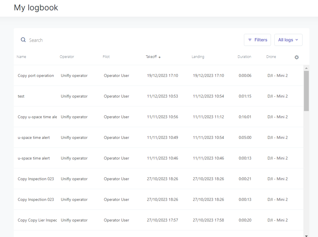
Logging of Take-off and Landing Events: Essential for logging purposes, every take-off and landing event is accurately recorded, ensuring a detailed and comprehensive flight logbook.
Together, these features ensure that during the “Fly” phase, operators have the tools necessary for efficient flight monitoring, maintaining optimal situational awareness throughout their operations.

Resolve (Tactical)
The “Resolve” stage is a crucial component of the Tactical phase in drone operations, focusing on the management of non-nominal events during the execution of operations and providing solutions to address these events where possible.
Key features include:
Tactical Conflict Detection: This feature enables the identification of potential conflicts between drones and between drones and manned aircraft. Operators receive alerts about these conflicts, and the spacing distances depend on what is defined for that type of airspace.
Tactical Conflict Resolution: Automated instructions are sent to drone operators to resolve detected conflicts swiftly, ensuring immediate and effective responses to maintain safety.
Conformance Alerts: Operators receive alerts to ensure compliance with regulations, such as avoiding restricted geofences or leaving the approved operational 4D volume.
Landing Instructions: When necessary, operators can receive landing instructions from authorities. These instructions must be acknowledged, and the flight status updated upon landing.
Emergency Declaration: Operators can declare emergencies, triggering alerts to other drone operators or authorities as required. This feature ensures that rapid response measures can be implemented in critical situations.
These features of the “Resolve” stage empower operators to address and mitigate issues promptly, ensuring the safe and compliant execution of drone flights.

Report (Post flight)
The “Report” stage is an essential part of the post-flight phase, enabling operators to review and manage flight data, logbooks, and incident reports.
Key functionalities include:
Flight Logbook: This feature allows users to access records of logged flights, which encompass critical details such as all take-off and landing times for drones and the associated pilots. This comprehensive logbook aids in maintaining detailed historical data for reference and compliance purposes.
Incidents Logbook: Any incidents that occurred and were recorded during the flight can be thoroughly documented and reviewed in the incidents logbook. This enables operators and their teams to analyse incidents, learn from them, and implement measures to enhance the overall safety culture.
Together, these features of the “Report” stage provide operators with the tools necessary for effective post-flight analysis, fostering an environment of continuous learning and improvement in operational safety.

Ready to elevate your airspace?

